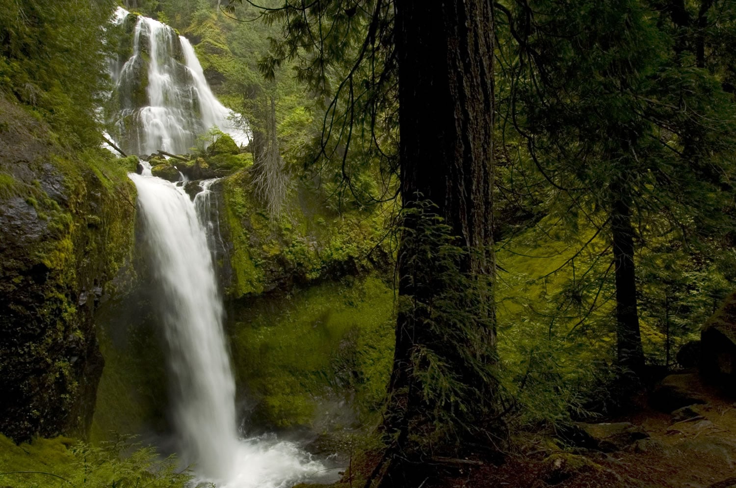
CARSON — Ken Shipley of Lake Oswego reached the viewpoint of Falls Creek Falls and paused.
“Isn’t that something. Wow!” said Shipley, seeing the 250-foot, three-tier cataract for the first time. “Just think of all the water coming over.”
Hiking companion Jim MacDevitt of Portland was seeing the falls for about his 20th time.
“What I like is it’s an easy trail that’s beautiful in spring with all the water and still beautiful in the fall — late September — when the vine maple turns color,” MacDevitt said.
Whatever the reasons for enjoying Falls Creek Falls, trails Nos. 152 and 152A in the southern Gifford Pinchot National Forest offer a marquee, loop outing at a time the high-country of the Cascades will be buried in snow for two to three more months.
At June Lake, elevation 3,440 feet on the south side of Mount St. Helens, there were 105 inches of snow on Wednesday. At Surprise Lakes, elevation 4,290 feet near Indian Heaven Wilderness, there were 120 inches.
It will be early-July before the mid-elevations melt out and mid-August before the high country is snow free in 2012.
In the meantime, there are places like Falls Creek Falls.
Hikers will want to do the Falls Creek trails sooner rather than later.
Dave Wickwire, recreation program manager for the Mount Adams District of the Gifford Pinchot forest, said the trails will close for about three weeks beginning May 21 while the trailhead is improved.
Two trailheads will be consolidated into one, with more parking, a toilet, picnic table and signs, he said.
Here is a look at three hikes, all relatively close together in the Wind River valley, which are snowfree, with an occasional trillium or dogwood already in bloom:
Falls Creek Falls loop — 3.95 miles; bottom elevation, 1,260 feet; top elevation, 1,979 feet — From the stoplight in downtown Carson, follow the Wind River Highway for 14.6 miles (just beyond Carson National Fish Hatchery) to the junction with Forest Service road No. 3062.
Turn on road No. 3062 and go 2.1 miles to the junction with road No. 057. Go right on road No. 057 to the trailhead.
Take trail No. 152A up Falls Creek for 0.48 mile to a suspension bridge, 1.34 miles to a bridge crossing a side creek and 1.54 miles to the viewpoint of the falls, at elevation 1,906 feet.
Head back 0.2 mile to a connecting trail that goes right (uphill) to link with Falls Creek trail No. 152. The connector trail gains 200 feet elevation in 0.42 mile.
At the junction, turn left on trail No. 152. This junction, at 1,979 feet, is the highest elevation of the loop. Head down for 1.31 miles to a substantial bridge crossing Falls Creek. To find the bridge, keeping look for a side trail to the left once Falls Creek No. 152 flattens and the tread gets wider. The elevation at the bridge is 1,394 feet.
Once across the bridge, turn left and go 0.48 mile to the trailhead.
Whistle Punk loop — 1.55 miles, elevation 1,139 feet, flat — This loop (Whistle Punk trail No. 59) wanders through a long-ago railroad logging site, passing remnants of timber-harvesting equipment and cables from the 1920s.
The short loop is .75 mile. Take the longer loop, which includes a boardwalk through a wetland. It’s flat, pleasant little walk that largely follows a 1913 railroad grade.
To find the trailhead, go the junction of the Wind River Highway and Hemlock Road at the community of Stabler. Turn west on to Hemlock Road and go 1.3 miles just beyond the Wind River Work Center. Turn right on road No. 43 at Hemlock Recreation Site and go 0.6 miles to the junction with road No. 4300417.
Turn right on to No. 417 and follow it 0.4 miles to the trailhead, which includes a rest room and picnic table.
Bunker Hill trail — 3.4 miles; bottom elevation, 1,200 feet; top elevation, 2,400 feet — To find the trailhead for Bunker Hill trail No. 145, follow the directions for Whistle Punk.
Once on road No. 417, go only 0.1 mile to a crossing of the Pacific Crest National Scenic Trail.
Bunker Hill is a free-standing little mountain on the edge of the old Wind River Nursery.
The trail to the top is a steep grind through the trees with little to see except one panoramic view down the Wind River valley from near the summit.
From road No. 417, follow the Pacific Crest trail east for a half mile to the junction with trail No. 145.
At the junction, trail No. 145 up Bunker Hill heads left while the Crest trail drops to the right.
Bunker Hill trail makes 11 switchbacks as it ascends the mini-peak.
At the top are concrete footings of a former fire lookout station.
The station was built about 1940 and abandoned in the 1950s.