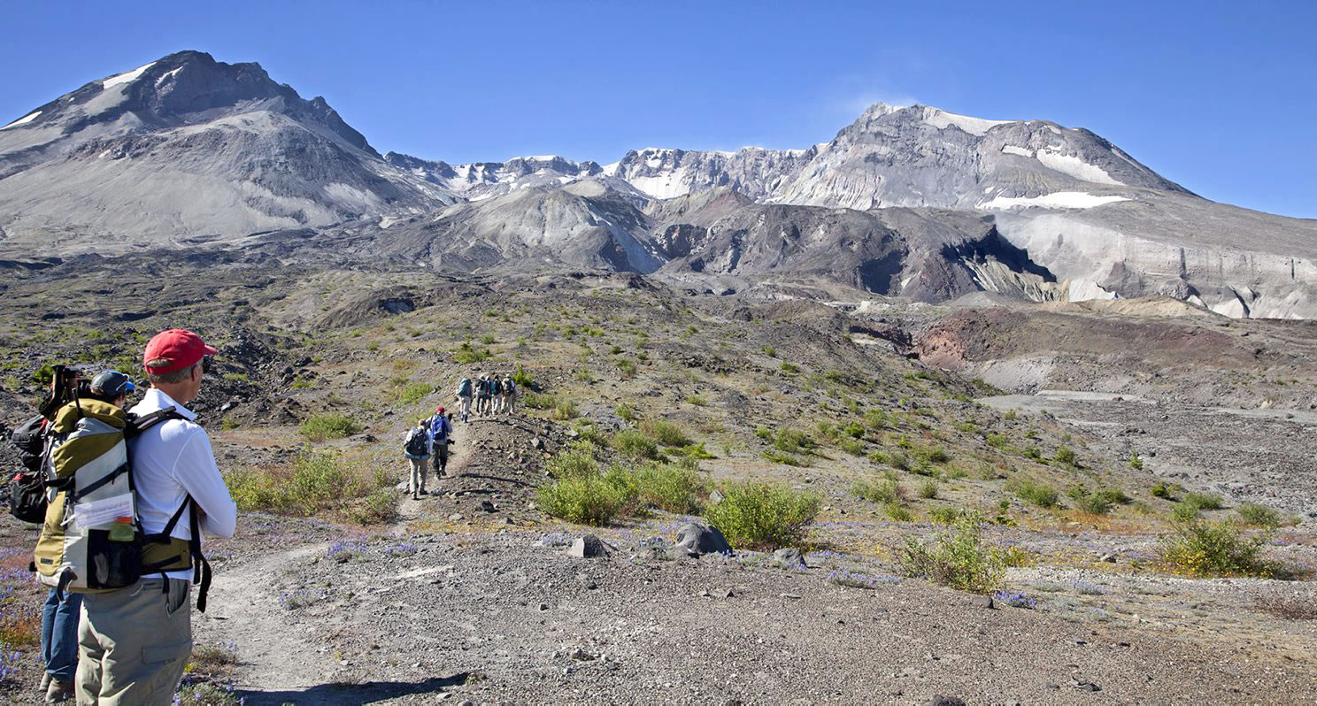
COUGAR — The final few yards of climbing to the crater view are the toughest, with hikers digging their boots into soft sandy pumice, taking care not to dislodge rocks.
But the view is worth the sweat-inducing slog.
The route — which is scheduled to open to the public next year — leads to a spectacular view into the crater of Mount St. Helens.
The scenery includes the heavily crevassed Crater Glacier, which flows around the lava dome, and rockfalls that tumble off the crater walls and send up angry plumes of dust.
“Oh my gosh. Big wow. It looks far bigger than I thought it would look like,” Maggie Woodward of Portland said when she glimpsed the lava dome during a recent guided hike.
Lindsey Karr, a guide with the Mount St. Helens Institute who led the crater-view hike, said she prefers the scenery there to the view from the summit of the volcano.
“I really like the pumice plain,” which is on the way to the crater view, Karr said. “It’s really beautiful, and I’m fascinated by the biology and ecology that’s going on. And there’s less people, too,” compared to the steady stream of hikers one encounters on the summit route.
The lack of crowds is partly because for now, the only way to reach the crater view is with a Mount St. Helens Institute guided hike that costs $300.
As early as next year, however, the Forest Service plans to open the route to the public under a fee system similar to that for climbing up the south side of the volcano to the summit.
In the years following Mount St. Helens’ 1980 eruption, the Forest Service repaired many obliterated trails and built others from scratch. Trail construction then slowed, but it has resumed in recent years, with several routes under consideration.
Planners originally hoped to establish a route to the top of the Sugar Bowl, a rounded landmark on the northeast side of the volcano. But the Sugar Bowl ascent was too steep and loose, so the alternative goes to a saddle between the Sugar Bowl and Loowit Falls. At 5,225 feet elevation, the saddle is 1,500 feet lower than the top of the Sugar Bowl — but the unobstructed view of the crater is still remarkable.
The 10-mile slog from Windy Ridge to the crater view gains 1,800 feet and has little shade, so MSHI hikers spend the previous night at a comfortable camp on a closed Forest Service spur off Road 99. Food and wine are provided, along with a campfire talk the night before.
At 6:30 a.m. the morning of the hike, the group drove to Windy Ridge, which is at the end of the part of Road 99 that’s open to the public.
The first two miles of the route descend a section of gravel road that’s closed to vehicles. From the bottom of the road, there are two trail alternatives to reach the crater view. Karr lead the group on the longer way in, via the Truman Trail 207, the Willow Spring Trail 207A and Loowit Trail 216.
As the hikers rounded a bend, Spirit Lake came into view. Above the lake loomed the jagged peaks of the Mount Margaret Backcountry.
This is blast zone central, with hardly a living tree in sight. A few springs surrounded by thickets of alder provide the only shade.
This time of year, the plain is pleasantly dotted with blue lupine and orange paint brush, but it’s much closer to a desert landscape than typical Northwest greenery.
From the Loowit Trail, Karr lead the group on a half-mile detour to the base of Loowit Falls, which drops about 180 feet, a white cascade against the gray and reddish rocks. Unfortunately for baked hikers, the canyon below the falls is too steep to descend so the stream is out of reach.
The hike to Loowit Falls is open to anyone and is a good alternative to the guided crater view trek, with one important shortcoming: From Loowit Falls, only a bit of the crater rim is visible.
The crater view route takes off from the Loowit Trail about one-quarter mile east of the Loowit Falls spur. It’s about 1 mile up to the crater viewpoint.
The lower part of the route is rocky and provides for relatively sure footing. Hikers pulled out binoculars to study some white blotches on the pumice about half a mile away. It turned out to be six mountain goats sunning themselves.
The upper part of the crater view route is loose pumice, reminiscent of the top of the summit climb.
The saddle at the top of the route is relatively flat and there’s plenty of space to spread out and rest. However, this hike is a reminder that Mount St. Helens can be sun-baked, ashy and barren — no cool forests or white snowy peaks here.
From the saddle, the original dome formed from 1980 to 1986 is front and center, 1 mile away, and parts of the second dome formed from 2004 to 2008 are visible behind it.
Woodward said the dome looks bigger than it does from the summit because it is views from the side, not from on top.
Vanja Dezelic and his wife, Tihana Fuss flew out from Cleveland just for the climb. Dezelic is a geologist, and Mount St. Helens was recommended in a book about volcanoes his wife gave him.
The dome is “bigger than you think it’s going to be,” Dezelic said.
“For me, the glacier is super cool,” Fuss said.
On the way out, Karr chose a shorter route back via the Loowit and Windy Trails. Taking that route for both directions would make a round-trip of 8 1/2 miles, not including a visit to Loowit Falls.
Back at camp, the hikers were weary but still in awe of what they’d seen.
“It’s fabulous,” said Linda Starr of Woodland. “It’s pretty special.”