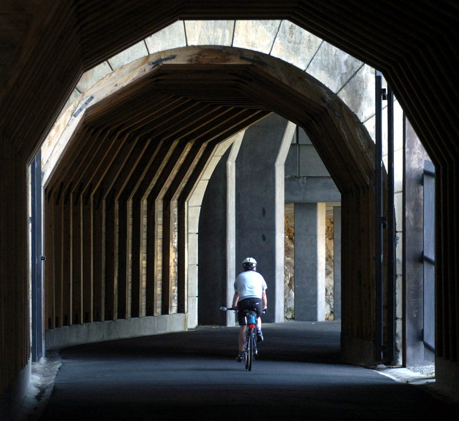
The Mosier Twin Tunnels offer unexpected thrills for cyclists exploring the Historic Columbia River Highway State Trail. (The Columbian files)Photo Gallery
If you enjoy taking in scenery while on two smoothly spinning wheels, check out these five paved bicycle trails in or near Clark County.
Never leave valuables in your car. Always bring plenty of water, snacks, sunscreen and a tire-repair kit.
Central Vancouver, 8 miles one way, 200 feet elevation gain.
This mother-of-all-local-trails packs a miniature epic into 8 crosstown miles. You’ll ride alongside scenic wetlands, forest nooks and crannies, backyards and condos, disc golfers and soccer players. You’ll face both signaled and nonsignaled roadway crossings as well as one freeway overpass. You’ll undoubtedly notice homeless tents and shopping carts near Andresen Road.
The Burnt Bridge Creek trail even offers a bit of a workout, with a few brief but steep elevations to attack — and downhill slopes to coast.
The west trailhead is where Fruit Valley Road meets Bernie Drive, south of Northwest 78th Street. On-street parking is on Bernie. There is one port-a-potty on site. Other trail entrances, with parking, are at Leverich Park off Leverich Park Way; Meadow Homes Park at 18th Street and General Anderson Avenue; and Devine Road off 18th Street.
The east trailhead is off Northeast 92nd Avenue at 19th Circle (near Meadowbrook Marsh park), with parking on 19th.
Southeast Portland and beyond, 21 miles one way, 200 feet elevation gain.
If you really want to stretch your legs while staying in the city, Portland’s Springwater Corridor offers the length you’re looking for. Pedal all the way from downtown Portland across the east side to Gresham and even Boring, Ore. — and then back again — along a former rail line. Like the Burnt Bridge Creek trail, the Springwater Corridor offers a bit of everything: ponds and forests, quiet streets and backyards, commercial corridors and, yes, some people without homes carving out a meager existence in the underbrush.
Hunt down a parking lot or on-street parking near the Oregon Museum of Science and Industry and the Tilikum Crossing. The trail heads south along the Willamette River and Oaks Amusement Park, before turning east where you must travel Sellwood neighborhood streets. Then the Springwater Corridor breaks for Gresham (mile 16, where a pleasant city park provides a good break) and Boring (mile 21, where there’s a simple parking area and restroom).
Alternative ride: For a signature Portland experience, try weaving around pedestrians while pedaling the 4-mile Waterfront loop, from the Tilikum Crossing on the south to the Steel Bridge on the north.
Chehalis and beyond, 15 miles one way to Rainbow Falls State Park with elevation gain of around 300 feet. Day use fee, $5. (Total length, 56 miles, but much of the path west of Pe Ell, mile 27, is rough, unimproved surface with some missing connections.)
This beautiful, rustic bike trail is worth a visit, and the 30-mile out-and-back to Rainbow Falls State Park may be the perfect picnic excursion for a summer day. The trailhead is off Interstate 5 at Exit 77 in Chehalis (about 1 hour, 15 minutes north of Vancouver), with other access points farther west in the towns of Littel and Adna.
Littel is where a new bike-path overpass completes a gap in the trail and lifts cyclists away from what’s been a difficult and dangerous roadway crossing.
Pavement gives way to compacted gravel after a few miles, but the path remains flat, easy and scenic while traversing farm fields, forests, villages and a couple of impressive pedestrian bridges over the Chehalis River. A trail spur connects with Rainbow Falls, a shady camping park that offers shelters, picnic tables and a little uphill hiking, but you’ll want to save your legs for the return trip.
Oregon side of the Columbia River Gorge, three separate segments, approximately 13 miles one way total, many ups and downs.
Oregon is working to restore, reopen and reconnect what used to be the only roadway along the south side of the Gorge. It’s a spectacularly scenic, wiggly, cliff-hugging route that was built between 1913 and 1922 with day tourism in mind, then largely abandoned in favor of the straighter, faster, lower-altitude interstate freeway in the 1950s.
Fortunately, the old highway has been rediscovered and re-imagined as a paved pedestrian-and-bike way that shows off some of the Gorge’s best scenery. Refurbishing the abandoned sections and building new connections has taken years and will take more, but you can inspect the stylish stonework and revealing vistas now.
The three sections are:
Cascade Locks to John B. Yeon State Park (6.5 miles), offering great views of Bonneville Dam from way-high-up trail pull-outs and one steep trail stairway fitted with bike tire grooves, where you must dismount and lug your bike up and down. Pause at Eagle Creek along the way. Park at or near Bridge of the Gods/Pacific Crest Trailhead in Cascade Locks.
Wyeth to Viento (6 miles). Roll past woodsy trailheads, scenic waterfalls and more sprawling views of the Gorge from altitudinous pull-outs. Consider parking at Starvation Creek and strolling a little ways up a trail spur to yet another beautiful waterfall.
Morning Briefing Newsletter
Get a rundown of the latest local and regional news every Mon-Fri morning.
Mosier to Hood River (5 miles). Exit I-84 at Mosier and follow the road as it curves down, around and up to the Mark O. Hatfield Trailhead. Soon after your westward journey begins you’ll arrive at the first of the historic Mosier Twin Tunnels, which would be a lot darker if they hadn’t been fitted with windows on the scenery by those original, clever highway builders. (Interpretive kiosks explain how the twin tunnels were engineered and restored.) As is, biking the tunnels is slightly spooky and thoroughly thrilling. Beyond the tunnels, watch for the eastern Gorge’s signature basalt columns.
Forty minutes west of Portland via Oregon Highway 26, 21 miles one way, 1,000-feet elevation gain total (700 of which are at one killer switchback).
The rail trail that starts in Banks is notable for gorgeous scenery and the remarkable Buxton Trestle: 700 feet of curving wooden skyway, 80 feet above Mendenhall Creek, giving cyclists a little sensation of riding through treetops. The trail features 13 bridges in all, and connects with L.L. Stub Stewart State Park. Don’t be surprised to share the way with horseback riders.
The Banks-Vernonia Trail is a gentle pleasure cruise until you approach mile 12 and the Tophill Trailhead, where a big ridge requires switchbacking at a pretty severe (but still paved) angle. No shame in getting off and pushing your bike up at this 700-foot rise.
Developed an appetite by now? Banks and Vernonia are quaint towns with pubs and eateries that love catering to weary, hungry, thirsty cyclists.
Morning Briefing Newsletter
Get a rundown of the latest local and regional news every Mon-Fri morning.