The U.S. Forest Service has announced its plan for the popular Cape Horn trail in the Columbia River Gorge, including a January-through-June closure on much of the route along the cliffs south of state Highway 14.
Appeals of the decision by Dan Harkenrider, Columbia River Gorge National Scenic Area manager, must be filed with the regional forester in Portland by Feb. 1.
The 5.5-mile route was created by hiking enthusiasts on federal land and private conservation trust lands over the past decade in western Skamania County. Hikers walk up 1.3-mile Cape Horn Road to complete a loop.
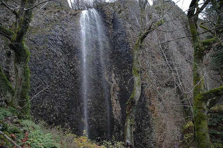
The trail starts at the park-and-ride lot at the junction of state Highway 14 and Salmon Falls Road, climbs to Pioneer Point atop Cape Horn, then drops to cross south of Highway 14 to spectacular bluffs above the Columbia River. It then passes underneath a waterfall before ending at the bottom of Cape Horn Road.
But several problems exist with the trail location, according to the Forest Service.
Among the troubles are poorly designed tread in places, crossings of wet areas and talus slopes, two grade-level crossings of state Highway 14 and proximity to a peregrine nesting site.
The Forest Service released an environmental assessment on Oct. 30 containing four alternatives for the trail. The alternatives included the seasonal closure or eliminating part of the route due to conflicts with sensitive lands and nesting peregrine falcons.
Harkenrider’s decision will result in the January-June closure from a spot called Fir View to the west end of Cape Horn Road. It puts the turnaround point at a location difficult to bypass.
Two environmental groups applauded Harkenrider’s compromise to keep the loop, yet still protect the peregrines.
“The plan impacts a lot of different stakeholders who all had to give a little,’’ said Ryan Ojerio, regional coordinator for the Washington Trails Association. “Ultimately the plan will pave the way for all of us to work together to improve and develop this spectacular trail. We’re hoping to schedule volunteer work parties as early as this spring.’’
Renee Tkach, outdoor program coordinator for Friends of the Columbia Gorge, echoed Ojerio.
“We applaud the Forest Service for approving a plan that keeps the loop trail open while taking extra measures to avoid negative impacts on sensitive resources like nesting peregrine falcons and talus slopes.’’
Dan Huntington of Washougal, one of the most-active advocates for the trail, supported the plan, with a caveat.
“The Forest Service is to be commended for this plan, although closing the lower half of the trail during most of its prime hiking season unnecessarily deprives the public of an exceptional hiking experience,’’ Huntington said.
Other aspects of Harkenrider’s decision are:
• Adding pedestrian underpasses of state Highway 14 at Salmon Falls Road and at the western crossing of Cape Horn trail and the highway.
• Re-routing the trail around talus slopes and wet areas.
• Requiring dogs be leashed.
• Adding permanent parking at Canyon Creek Road and temporary parking at Strunk Road. There would be restrooms at both parking spots and a wheelchair-accessible trail to a scenic overlook at Strunk Road.